Video of squeaking sand

White Park Bay in Northern Ireland is a pleasant place for walking and there is lots of interesting geology: raised beach with caves in chalk, lots of flint nodules, basaltic rocks, fluvial sand enriched in heavy minerals, and last but not least, a squeaking sand.

It was fun to drag boots through the sand and listen to the music sand grains are making. I took a short video to record that squeaking sound:

This sand was not squeaking everywhere. The sand has to be dry but not very loose. Squeaking part of the beach was relatively firm and easy to walk on.

This squeaking sound is pretty common and it is different from booming sand which is associated with sandy and very dry deserts with loose sand. Booming sound also has a lower pitch. It is still an open question what causes the squeaking and booming sounds but it seems to be obvious enough that friction between quartz grains is the triggering mechanism. It is thought that grains have to be well-rounded, well-sorted, and free of dirt. If you want to know more about squeaking and booming sands, check out this article.

Sole marks in the Old Red

This outcrop of sandstone and conglomerate is located by the sea in southern Ireland near Bunmahon. These clastic sediments were deposited during the Devonian. Such reddish sedimentary layers are widely known by their name Old Red or Old Red Sandstone. I am used to rocks like this because they are very common in Estonia, although our redbeds are not nearly as strongly cemented as they are in Ireland.

Sedimentary layers are originally horizontal. As you can see, these are clearly not. I assure you that the inkpen on the picture is nearly horizontally placed and the dip of the rock layers is almost vertical. In this case, how can you tell where is the original stratigraphical way up? It is often hard to tell but in this particular instance it is not difficult at all. I took this picture because here we can see a very good example of a sole mark. I am talking about the grooves in the fine-grained sandstone which are filled with coarse sandstone and conglomerate.

I find it very difficult to imagine how on earth can it happen that the conglomerate bed gets deposited first with these sharp and clearly unstable (the lowest one) humps and after that came sandstone that covered them. On the other hand, it seems plausible to assume that sandstone was deposited first, grooves were somehow formed on top of it and they were filled with conglomerate. This is what sole marks seem to be for me — pure logical imagination.

http://picasaweb.google.com/107509377372007544953/Ireland#5758773042825068866

Thousands of sand sculptures

I am not a great fan of biology, especially when it comes to worms. However, in one good day when wandering across an intertidal zone near Loughshinny in Ireland I stumbled upon thousands of casts created by lugworms. This sight was really spectacular.

http://picasaweb.google.com/107509377372007544953/Ireland#5758425855166713266
An overview of the beach near Loughshinny which is underwater in a high tide. All these little dots are lugworm casts.

http://picasaweb.google.com/107509377372007544953/Ireland#5758425967760011570
Closeup of these casts. They are composed of beach sand which lugworms pushed through their body to extract nutrients from the sand. It seems to be a pretty painful way to eat.

http://picasaweb.google.com/107509377372007544953/Ireland#5758425948899540530
The worms live in sand in a U-shaped burrow. You can see here both casts and holes. One end of the worm is beneath the hole, that’s the place where it takes in sand and another end is beneath the sand squiggle which resembles toothpaste pressed out of a tube.

I was even patient or lucky enough to see how one of these things came to be. I saw about a centimeter of sand suddenly pushed out of the beach sand. Hence, the formation process is most likely intermittent — about a centimeter at a time and takes some time during the low tide conditions. During high tide all these squiggles are wiped away by waves and worms have to take a rest and wait for the next low tide to eat again.

I preferred to leave the worms themselves alone. So, there will be no photos of the authors of these sand sculptures but they should resemble other common earthworms which are highly valued by fishermen who use them as a fish bait.

Giant’s Causeway

Giant’s Causeway is the most popular geological tourist attraction in the island of Ireland and it was one of the places I definitely wanted to see. I have to say that it really is worth it.

Columnar basalt in itself is not an uncommon phenomenon but here it is especially well exposed and there is actually much more geologically interesting stuff to see than just the small cape named the Giant’s Causeway.

The weather was just awful — it was cold, windy, and rained all the time. I guess it was bad even according to Irish standards because there were surprisingly small number of visitors which was good.

http://picasaweb.google.com/107509377372007544953/Ireland#5755679505310466834
Reddish layer of laterite (Port na Spaniagh laterite) underlying the Causeway basalts. Laterite is weathered basalt. In this case it indicates that there is a time gap between the formations of basalt layers.

http://picasaweb.google.com/107509377372007544953/Ireland#5755679491363847634
Closeup of laterite. Laterite is red because of oxidized iron. Iron is plentiful in mafic rocks like basalt.
http://picasaweb.google.com/107509377372007544953/Ireland#5755679499636689410
Spheroidally weathered basalt.
http://picasaweb.google.com/107509377372007544953/Ireland#5755679641366670258
This seastack is known as Camel’s back. I guess it is a Bactrian camel — it has two humps. Geologically it is a dike cutting through the basalts underlying the Causeway.
http://picasaweb.google.com/107509377372007544953/Ireland#5755679712907545954
There is even littlebit of sand. Giant’s Causeway is a small cape in the background.
http://picasaweb.google.com/107509377372007544953/Ireland#5755679723704864450
It seems to consist mollusk shells and basalt fragments.
http://picasaweb.google.com/107509377372007544953/Ireland#5755680149443967634
The columns are the real Giant’s Causeway, but the boulders resting on top of them probably represent the upper curvi-columnar (known also as entablature) part of the Causeway basalt formation.
http://picasaweb.google.com/107509377372007544953/Ireland#5755679858067423794
A boulder of curvi- or pseudo-columnar basalt. It is not as regularly jointed as the main sequence because of faster cooling. This part of the sequence was closer to the surface.

Columnar basalt at Giant's Causeway
Giant’s Causeway. It really is amazing even if you are prepared to see something like this.

http://picasaweb.google.com/107509377372007544953/Ireland#5755680201708222018
The basalt forming the Giants’s Causeway was originally a lava lake filling a topographical depression.
http://picasaweb.google.com/107509377372007544953/Ireland#5755680303316870658
Columns are the result of contraction — solid rock is denser and takes less space than liquid lava.
http://picasaweb.google.com/107509377372007544953/Ireland#5755680309413444450
Lava layer loses heat through their bottom and top surfaces where the shinkage joints start to develop.
http://picasaweb.google.com/107509377372007544953/Ireland#5755680064970623618
The columns have a variable number (3-7) of sides.
http://picasaweb.google.com/107509377372007544953/Ireland#5755679835071347426
A sideview of the Giant’s Causeway. It can be seen that because of contraction there are also horizontal joints (ball and socket joints) separating each column into many shorter colums.
http://picasaweb.google.com/107509377372007544953/Ireland#5755679931225861122
This outcrop known as the Giant’s Organ is located few hundred meters away from the Causeway. I guess it is not reached by many visitors of the Causeway, but geologically it is very interesting outcrop because here one can see the whole sequence of regular columns and curvi-columnar section directly above it. The term “entablature”, which is borrowed from architecture, was first used to describe the upper section of this outcrop by Sergei Tomkeieff who is perhaps well-known to petrologists because of his Dictionary of Petrology. He called the regular columns below “a colonnade”.
http://picasaweb.google.com/107509377372007544953/Ireland#5755679987053228162
Unfortunately it rained so heavily that I couldn’t take a clear picture of the Organ but hopefully you can get an idea how it looks. Here you can see that the sequence can be separated into three parts The upper layer above the entablature was named “pseudo-columnar” by Tomkeieff.

Dog’s Bay in Connemara

One of the places I was recommended to visit in Ireland is Dog’s Bay in Connemara. It is especially interesting place for sand enthusiasts because the beach sand is composed of various biogenic grains. Thanks to Carla Lagendijk I already had a sample of this interesting sand in my collection and I have written a short post about this sand. This sand covers extensive area as you can see below and it is not confined to Dog’s Bay. I saw similarly white but much coarser sand (maerl) in Mannin Bay nearby which I will describe in another post.

http://picasaweb.google.com/107509377372007544953/Ireland#5754567629878538338
http://picasaweb.google.com/107509377372007544953/Ireland#5754567630621821410
http://picasaweb.google.com/107509377372007544953/Ireland#5754567629954629586
The rocks on the beach are granitic. This is local bedrock, not glacial erratics.
http://picasaweb.google.com/107509377372007544953/Ireland#5754567703961574658
http://picasaweb.google.com/107509377372007544953/Ireland#5754567700401465250
Closeup of red granite with K-feldspar phenocrysts.
http://picasaweb.google.com/107509377372007544953/Ireland#5754567701380420258
http://picasaweb.google.com/107509377372007544953/Ireland#5754567805000014354
http://picasaweb.google.com/107509377372007544953/Ireland#5754567752329671506
http://picasaweb.google.com/107509377372007544953/Ireland#5754567801715389170
Almost like Bahama.
http://picasaweb.google.com/107509377372007544953/Ireland#5754567808069915314
Me and one of the places every sand collector should visit before they die. This was a joke, in case you did not understand, book titles like that make me sick.
http://picasaweb.google.com/107509377372007544953/Ireland#5754567880960590770
http://picasaweb.google.com/107509377372007544953/Ireland#5754567871471664034

Bedded chert in Cyprus

Governor’s Beach in the southern coast of Cyprus exhibits a nice exposure of interbedded chalk and chert. Chalk is soft, porous, and fine-grained marine limestone composed of calcareous tests of various microorganisms.

An outcrop of bedded chert and chalk
White chalk and gray chert.

Chert is dense and hard sedimentary rock, consisting mostly microcrystalline quartz. These rocks may frequently occur together. Chert is either nodular or forms layers (bedded chert).

Siliceous material forming chert layers is thought to represent siliceous material deposited on the seafloor and consisting of siliceous tests of radiolarians and diatoms which upon burial formed chert.

http://picasaweb.google.com/107509377372007544953/Cyprus2#5737568579272056418
Chert layers stand out because they are much harder than soft chalk layers.
http://picasaweb.google.com/107509377372007544953/Cyprus2#5737568446404429922
http://picasaweb.google.com/107509377372007544953/Cyprus2#5737568518417904770
Closeup of chert.
http://picasaweb.google.com/107509377372007544953/Cyprus2#5737568510343325250
An example of boudinage — chert layer seems to be stretched, it is not anymore continuous.
http://picasaweb.google.com/107509377372007544953/Cyprus2#5737568550554275714
Chert between slightly brecciated chalk. Sometimes chert that occurs in chalk is named flint. This term does not have a precise definition but it is often reserved for pure and very hard chert examples. Hence, I would hesitate to name that way the examples shown above (and in the middle of this boudin) but this dark gray chert probably qualifies. So, let’s say it is flint.
http://picasaweb.google.com/107509377372007544953/Cyprus2#5737568809532627074
A closeup of the same flint boudin.
http://picasaweb.google.com/107509377372007544953/Cyprus2#5737568587108220690
Here again the color of chert varies. I guess it shows the degree of purity. Pale gray chert is probably impure — contains chalk.
http://picasaweb.google.com/107509377372007544953/Cyprus2#5737568629298193970
Boudinaged bedded chert and chalk.

Meteorite crater near my home

My home country is number one in the world at least in one thing. Estonia is probably the most densely impact cratered country. Estonia hosts at least 5 craters/crater fields (and some unconfirmed holes in the ground as well) in a relatively small area (45,227 km2). There are several reasons which at least partly explain why this is the case but I will leave it for another day. Today I want to show you some pictures of one of the craters which happens to be only 15 km away from my summer home where I live at the moment.

This is Ilumetsa Crater in SE Estonia. I visited the place today to take some fresh pictures for my blog. This is actually a crater field, at least two craters are confirmed to be of impact origin. The largest crater is 80 meters wide from rim to rim and 12.5 meters deep (including 2.5 meters of peat covering the bottom of the crater). The rim of the crater is 1…4.5 meters high. The crater is 6,600 years old. So the formation of the crater field is geologically a relatively recent event (from the Holocene). The age of the crater is determined by radiocarbon dating and palynological means. There is shattered bedrock composed of weakly cemented Devonian sandstone below the crater. About 30 meters of the bedrock is disturbed by the impact event. So far, no meteoritic material has been found directly at the impact sites but microimpactites have been found from a peat layer (6,600 years old) in a bog nearby.

http://picasaweb.google.com/107509377372007544953/Estonia#5751718228308449714
Largest crater (Põrguhaud) of the Ilumetsa crater field.

http://picasaweb.google.com/107509377372007544953/Estonia#5751718047597596258
http://picasaweb.google.com/107509377372007544953/Estonia#5751718282370934658
http://picasaweb.google.com/107509377372007544953/Estonia#5751718235726549186
http://picasaweb.google.com/107509377372007544953/Estonia#5751717883339339170
Most people enjoy mythological nonsense much more than geology. This place has been associated with devils since the ancient times. Põrguhaud means ‘hellgrave’ and I read that people did not dare to go near the crater during nighttime. Well, at least old Estonians were smart enough to understand that there is something wrong with the place. However, little did they know that this hole has more to do with celestial than hellish powers. Anyway, this friendly looking chap here is how devil should look according to a sculptor.
http://picasaweb.google.com/107509377372007544953/Estonia#5751717948126038834
There are more wooden animals by the hiking trail leading to the crater.
http://picasaweb.google.com/107509377372007544953/Estonia#5751717995859767778
http://picasaweb.google.com/107509377372007544953/Estonia#5751718026419109730

Sheeted dikes of the Troodos Ophiolite

Sheeted dike complex is a swarm of subparallel tabular igneous intrusions (dikes). Sheeted dikes form a significant part of the oceanic crust.

They are pathways through which molten basaltic magma rose from the mantle to the seafloor where it solidified as a pillow lava. Some of the magma did not reach to the surface and solidified as dikes. Dikes in sheeted dikes complex are so closely spaced that there is nothing else than just one dike next to another.

These dikes cut each other as each one of them represents a narrow sheet of new oceanic crust that had to force its way between older dikes already formed and solidified.

The images below are from Cyprus (the Troodos Ophiolite). These dikes formed roughly 90 Ma and were once part of a floor of the Tethys Ocean.

Sheeted dikes of a variable width.

http://picasaweb.google.com/107509377372007544953/Cyprus2#5737570414911046002
One dike next to another.

http://picasaweb.google.com/107509377372007544953/Cyprus2#5737570452984508162

http://picasaweb.google.com/107509377372007544953/Cyprus2#5737570468076860738
Dikes side on.

http://picasaweb.google.com/107509377372007544953/Cyprus2#5737570320923065954
The grains (mostly white plagioclase and black pyroxene) are visible to the naked eye. This rock type is diabase (dolerite) which is compositionally equal to basalt but has coarser texture.

http://picasaweb.google.com/107509377372007544953/Cyprus2#5737570500418336034
Dike with a chilled margin (darker black) is younger and was intruded into the dike to its right.

http://picasaweb.google.com/107509377372007544953/Cyprus2#5737570532802780018

http://picasaweb.google.com/107509377372007544953/Cyprus2#5737570542258161634
More chilled basaltic margins in contact with a diabase dike.

http://picasaweb.google.com/107509377372007544953/Cyprus2#5737570609987788994

Here are the coordinates of the outcrop: 34.95348 N, 32.99915 E.

Massive pyrite in Cyprus

There are many holes in the ground in Cyprus which were once filled with massive pyrite deposited by black smokers on the seafloor. These holes are abandoned open-pit mines which now host lakes in the bottom.

http://picasaweb.google.com/107509377372007544953/Cyprus2#5737568019351881474
These lakes may be astonishingly beautiful. Unfortunately, photos simply can not describe that deep red color adequately enough. This lake occupies the bottom of the Kampia mine.

http://picasaweb.google.com/107509377372007544953/Cyprus2#5737568046712405378
Beautiful it may be but I would not go swimming there. I wonder what the pH of the water could be? It is definitely strongly acidic. I did not attempt to go down there. The slopes of the quarry do not seem to be very stable.

http://picasaweb.google.com/107509377372007544953/Cyprus2#5737568061661654658
Almost all of the pyrite is gone, dug out and most likely used to make sulfuric acid which was used in the batteries of our cars. But I was still able to find some nice specimens.

http://picasaweb.google.com/107509377372007544953/Cyprus2#5737567359296348098
Mathiatis mine is not as beautifully red but it was possible to safely visit the bottom of the quarry.

http://picasaweb.google.com/107509377372007544953/Cyprus2#5737567444071165666
No massive pyrite is left for us to see. It costs money, you know. Cypriots are no idiots to leave it there. This was closest to massive pyrite I was able to find.

http://picasaweb.google.com/107509377372007544953/Cyprus2#5737567417400375058
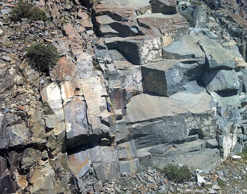
But I found some nice examples of a stockwork. This is basaltic seafloor below the pyritic lens through which hot and metal bearing water rose upward. Stockwork is a mixture of basalt with hydrothermal pyrite and quartz (lower right).

http://picasaweb.google.com/107509377372007544953/Cyprus2#5737567464412197538
Nice reddish quartz crystals. Red color is probably caused by the hydrothermal alteration of a metal bearing sediment umber deposited between pillows.

http://picasaweb.google.com/107509377372007544953/Cyprus2#5737567472382830866
A road down to the quarry is paved with slag.

http://picasaweb.google.com/107509377372007544953/Cyprus2#5737567364938264402
Beautiful poppies growing near the rim of the mine.

http://picasaweb.google.com/107509377372007544953/Cyprus2#5737565800616120706
Sulfide ore is called “massive” because it contains little else than pure pyrite. Here is an example of a large block of pyrite (pyrite as a rock) in a park behind the visitors center in the village of Troodos (far away from the mines described above).

Ultramafic lava knoll in Cyprus

I visited a prominent dark-colored knoll in Cyprus which is mostly composed of olivine. It is probably made of mantle material, right? Ancually no, it is not. It seems to be part of a lava flow.

The knoll is located near village Margi (15 km S of Nicosia). Olivine makes up about 60% of the rock in places but it grades out relatively quickly to near zero upwards which indicates that olivine phenocrysts probably formed by gravitational settling and accumulation in a topographic depression which acted as a trap to the more dense olivine crystals. It would be very difficult to find another explanation because lavas that rich in olivine are not known at present. Ultramafic lavas did exist in the geological past when the Earth’s heatflow was much higher. Such ultramafic lavas are known as komatiites but they mostly formed in the Archean. Since that time, Earth has cooled considerably and lavas with ultramafic composition can not form (there is not enough heat to melt large enough part of mantle rocks).

That may be all fine and understandable but one thing is unclear for me. How should I name such rocks? They are not basaltic rocks according to the TAS diagram. Is this diagram applicable in this case or should I just say that it is olivine cumulate lava without attempting to name it more precisely? Anyway, this seems to be yet another example that defiantly demonstrates how many pitfalls our common classification schemes contain.

http://picasaweb.google.com/107509377372007544953/Cyprus2#5737567602621730546
Example of a relief inversion? This knoll parhaps once filled a topographic depression.

http://picasaweb.google.com/107509377372007544953/Cyprus2#5737567610197029666
Closer looks reveales that the rocks are dark green because of abundant olivine phenocrysts about a millimeter in size.

http://picasaweb.google.com/107509377372007544953/Cyprus2#5737567640460119202
Obviously, I am not the first geologist here. Holes left by coring are easily spotted and in my opinion represent a problem which deserves a longer discussion. I do not think that there is something wrong with taking samples for scientific study but I definitely think that it should be used only if absolutely necessary. And maybe some efforts should be made to hide these holes. Otherwise, geologists in the long run risk the anger of public for their reckless “littering” and distructing of natural sights which will remain visible for a long time. I’ve seen such holes in many places.

http://picasaweb.google.com/107509377372007544953/Cyprus2#5737567747098543250
Here is another example (five coring holes). Can someone help to explain what kind of structure it is and how to interpret it?

http://picasaweb.google.com/107509377372007544953/Cyprus2#5737567628092751138
I am not sure it is correct interpretation but I think that these layers might be individual lava flows?

http://picasaweb.google.com/107509377372007544953/Cyprus2#5737567720399146594

http://picasaweb.google.com/107509377372007544953/Cyprus2#5737567736382053810

http://picasaweb.google.com/107509377372007544953/Cyprus2#5737567749980420770