Allochthonous and authigenic

Geologists apply the terms allochthonous and autochthonous to various different phenomena which have common characteristics. “Allochthonous” refers to something that has formed elsewhere. This “something” can be a huge mountain block that has been pushed tectonically atop of another block. Or it can refer to mineral grains or rock fragments that were previously parts of another rock which have since decayed and liberated the fragmants. These grains were then picked up by running water, carried to another place, and deposited as an allochthonous (or allogenic) sediment.

Thrust fault
This is a thrust fault from the Spanish Pyrenees. Siltstone formation (upper dark layer) is pushed on top of gray limestone formation which is actually younger and should be on top of siltstone in a normal succession. Siltstone is clearly allochthonous because it is removed from its original position.

Conversely, sediments that formed in place are called autochthonous or authigenic. It does not mean that the material these sediments or rocks are made of can not be from an external source (it usually is) but the resulting rock or its particles did not exist in this form as part of a pre-existing rocks. For example, quartz grains in sandstone were already in existence inside granite before this rock weathered and liberated these grains which were then transported to another place and deposited as sand. These quartz grains are allochthonous. However, sodium ions that were part of the same granite were liberated as well but they combined with chlorine ions to become rock salt. This is entirely different material that was not present in granite. Hence, rock salt is said to be an autochthonous chemical sediment.

http://picasaweb.google.com/107509377372007544953/2015#6190953934974355170
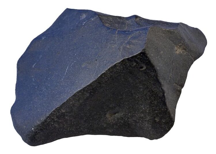
conglomerate is a sedimentary rock which is composed of allochthonous material. Width of sample from Norway is 9 cm.

The bulk of sediments are allochthonous. They are usually referred to as detrital or clastic sediments. Common allochthonous sediments are sand, silt, clay, and gravel. On the other hand, the vast majority of the Earth’s upper crust is autochthonous because the upper part of the crust tends to be relatively young and is usually composed of sedimentary rocks which generally have not moved since they were deposited. Things are different deeper in the crust. Metamorphic rocks beneath the thin veneer of sedimentary rocks are usually formed as a result of regional metamorphism which may include several mountain building episodes which tend to move large blocks of the crust out of its original position. However, these rocks are usually so old, often poorly exposed, and may have suffered multiple episodes of metamorphic overprinting which makes it very difficult to understand the bigger picture. It is a better idea to go and see some younger mountain range up-close if you want to see allochthonous parts of the crust.

Gypsum is an authigenic sedimentary rock. It is an evaporite that precipitated out of saline water. Outcrop is located in Cyprus.

Are “autochthonous” and “authigenic” (or “allochthonous” and “allogenic”) entirely synonymous? Actually not. There is a slight difference. Authigenic refers to constituents (sand grains and other sediments) rather than whole formations. Therefore, it is more correct to talk about allochthonous crustal blocks and authigenic sediments1. However, in real life most people are not so pedantic (or correct) and seem to use especially the term “allochthonous” in both situations.

References

1. Jackson, J. A. (1997). Glossary of Geology, 4th Edition. American Geological Institute.

Racetrack Playa and moving rocks

Racetrack Playa is a dry lake in Death Valley. It is home to a geological wonder — moving or sailing rocks. For me, the playa itself without the moving rocks was already quite an experience. The surface of the playa is almost perfectly flat (northern end is few centimeters higher) and firm. There is very easy to walk although it is clear that sometimes after heavy rain the playa must be wet or covered with shallow water body. Racetrack Playa is an endorheic basin which means that there is no outflow. The playa collects water and mud that originates from the surrounding mountains. Water disappears quickly because Death Valley has a hot desert climate, leaving behind dry muddy surface with countless polygonal mudcracks (polygons generally less than 10 cm in diameter).

It is obvious that Racetrack Playa is sometimes covered with water not only because its surface is muddy but also because there are rocks on the playa surface which apparently are moving along the surface, leaving behind clear tracks. This can happen only when the surface is saturated with water. As much as I know, there is no certainty about the mechanism that moves the rocks. It is generally believed that it must be a very strong gust of wind that initiates the movement on the wet and slippery surface (there is much less push needed to keep the rocks moving, initiating the movement is the hardest part). I support the view that rocks are moving primarily because of wind although I have to admit that it is very hard to imagine wind that is so strong. Some rocks are really big and heavy. It has to be one hell of an environment there when these things are happening. It is no wonder that no one has ever witnessed the process.

http://picasaweb.google.com/107509377372007544953/California02#5872323506247910018
The surface of the playa is firm and thoroughly covered with mudcracks. Average mud polygon is about 7 cm in diameter.

http://picasaweb.google.com/107509377372007544953/California02#5872323491421476850
Very flat surface of the playa has larger rocks here and there that are obviously moving sometimes. Most of them have clear tracks behind that show where they came from.
http://picasaweb.google.com/107509377372007544953/California02#5872323502904220050
Some rocks are really huge. Note that this rock has no track. So it was not moving during the last time when smaller rocks did slide and its older tracks have been erased by flooding. But sometimes it too has to move because somehow it managed to travel here. I wonder how? Honestly, how strong wind do we need to move a boulder like that?
http://picasaweb.google.com/107509377372007544953/California02#5872323527102725058
Racetrack Playa has many such sliding rocks. Most of them are concentrated on the SE part of the playa where the source of these rocks is located.
http://picasaweb.google.com/107509377372007544953/California02#5872323536224039042
Most moving rocks are composed of gray dolomite.
http://picasaweb.google.com/107509377372007544953/California02#5872323545757682786
This one is no small rock either. It’s me for scale again.

Racetrack Playa is in Death Valley National Park but it is somewhat harder to access than many other tourist attractions there. It is an isolated and remote valley 27 miles away from Ubehebe Craters where the paved road ends. However, don’t let it scare you. It is quite possible to go there even with a small car. I have read that this rough road is notorious for puncturing tires of small cars but it can really happen anywhere. It happened to me in Death Valley as well but not on a gravel road. It was paved road near Stovepipe Wells. When that happened I thought that I have a nasty and possibly time-consuming problem at hand because the temporary tire is really only a temporary solution in such conditions and it was Sunday. In Europe, people are not moving their lazy ass in Sunday but America seems to be somewhat different, help was actually nearby in the valley. There is a man working at the Chevron of Furnace Creek who quickly repaired the tire for $20. Thanks, you saved me lots of valuable time!

Update

It seems that we finally have a plausible explanation about what actually moves these rocks. It is not wind or more precisely it is not wind alone. It could not be because there are really no gusts that strong to moves these rocks. It seems to be ice that is doing the pushing job. You can read more about it here.

Tallest mountain in the world

Highest mountain, as we all know, is Mount Everest (8848 meters above mean sea level) in the Himalayas. However, there are several different ways to measure the height of a mountain. One alternative way is to measure the farthest point of the Earth’s surface from the center of the Earth. Even Kilimanjaro, the highest mountain of Africa which stands only 5895 meters above mean sea level, is higher than is Mount Everest if measured that way. And the record holder is Chimborazo (6268 meters above sea level) in Ecuador.

These mountains stand so high from the center of the Earth because they are located almost at the equator. Earth is slightly flattened sphere which means that areas at the equator are farther from the center than are polar areas. Hence, equatorial mountains have an unfair advantage over the summits at higher latitudes.

Measuring the height of a mountain from the center of the Earth is understandably very theoretical and perhaps even useless approach. I have never heard that anyone seriously thinks that Chimborazo is the highest mountain on Earth. But the list of possible ways to measure the might and height of a mountain does not end here. Another way to do it is to measure the height from the base of the mountain to its summit. Such an approach could be attractive to geologists because in some cases it gives really much better representation of the real height of a mountain.

It does not make much sense to measure the height of oceanic islands from the mean sea level. Sea level is no permanent marker anyway. It fluctuates in geological time and island volcanoes really do not care about the sea level. They start growing usually from the abyssal plain which is some 5000 meters below the sea level. It doesn’t do much justice to kilometers high and very voluminous oceanic island if we say that it is just a mere 100 meter high rock in the sea.

Oceanic islands are indeed the highest or perhaps I should say tallest mountains in the world. Highest and most voluminous oceanic island is Hawaii which is composed of several volcanoes, highest of them are Mauna Kea and Mauna Loa. Mauna Loa is the most voluminous, but Mauna Kea reaches few tens of meters higher. Here is the summit of Mauna Kea which stands 4205 meters above sea level, but its height from its base is more than 10 kilometers!

http://picasaweb.google.com/107509377372007544953/Hawaii#5870808539507438610

The summit of Mauna Kea is a cinder cone. Its appearance and the angle of slopes may be somewhat misleading because the bulk of the massive island is composed of basaltic lava, not pyroclasts. And its slopes are way more gentle because basalt flows easily and composes mountain with a very large base. I climbed the summit which was quite easy because you actually have to climb less than 100 meters. Mauna Kea has one of the best conditions for land-based astronomical observatories. There are lots of telescopes very close to the summit and obviously there is a road leading to them which means that one can almost drive to the summit.

Ventifacts and dreikanters

Ventifacts are sand-blasted rocks. They are typically faceted and often display parallel grooves carved by wind-blown sand. Ventifacts are common in desert environments where there is enough rocks and sand and little vegetation to keep the sand in place. Strong winds are also needed to lift and carry sand grains.

Dreikanter ventifact
Dreikanter is a rock polished by wind-blown sand that has three faces. Width of the rock is 7 cm.

During my recent visit to California I visited a small hill or ridge in Death Valley which is covered with thousands of nice examples of ventifacts. Not surprisingly, this ridge is known as Ventifact Ridge. It was indeed very windy that day and there were lots of rocks and enough sand to blast them.

Well faceted ventifacts are called dreikanters (if there are three wind-blown faces) or sometimes zweikanters or einkanters (two and one faces, respectively). This is obviously German language which provides the prefixes ein, zwei, and drei. Ventifacts can be sometimes used to determine the dominant direction of wind. The direction of parallel grooves needs to be measured for that.

Ventifact Ridge does not seem to be among the important natural tourist attractions of Death Valley. It is just an ordinary hill and there are no signs pointing to it. Perhaps because the terms “ventifact” and “dreikanter” are virtually unheard of to the general public. However, geologically this is really interesting place which I recommend to visit if you have a plan to go to Death Valley.

http://picasaweb.google.com/107509377372007544953/California02#5870445244134723490
This striated rock is much larger (width approximately 70 cm) example of ventifact.
http://picasaweb.google.com/107509377372007544953/California02#5870445246120076818
Ventifacts often have more than one sand-blasted faces and sharp edges separating them. Width of the rock is about 60 cm.
http://picasaweb.google.com/107509377372007544953/California02#5870445287230633874
These ventifacts are carved out of mafic vesicular volcanic rock. Width of the rock is 60 cm.
http://picasaweb.google.com/107509377372007544953/California02#5870445287465146322
The whole ridge is covered with variously sized ventifacts. Amargosa Range with colorful rocks of the Artists Palette is in the background.

Videos of flowing lava

Few weeks ago while I was still in Hawaii I posted some photos of glowing red hot lava of Kilauea volcano. It was definitely the highlight of my trip to Hawaii to see a volcanic eruption and moving lava from such a close range. Unfortunately, it was the April Fools’ Day when I published these photos which made some people suspicious that I photoshopped myself onto these images. I take this as a compliment that I am either such a good photoshopper or that my photos were impressive enough that it was hard to believe that I really was there.

But how can I prove that there are no sneaky tricks? I really don’t know. I have some videos but there is only lava, not me. It apparently is just a matter of belief. But I would like to show these videos anyway. Not because they prove anything but because they demonstrate nicely how quickly lava cools, how quickly it moves, and how ropy pahoehoe forms. I apologize for the quality. My DSLR has no video capability. So I had to rely on my hand-held iPhone instead.


This video demonstrates how new lava tongues start from a small breakout of older flow that already has a solidified crust. Lava is glowing very brightly at first but its outer surface loses heat rapidly. It turns yellow a mere second or two later and yellow tone also won’t last long before red becomes dominant. Lava spreads laterally as it breaks free and finally wrinkles typical to pahoehoe lava start to form as the outer solidified crust is pushed forward by the drag of moving lava inside the lava tongue. You can see that it takes a surprisingly little time until the outer surface turns black. Lava is dense which means that we can not sink into it. You can step onto newly formed lava flow if its outer surface is not glowing anymore. I tried it without falling through the surface. However, glowing lava is soft enough so that it can be deformed with a hard hand-held object like a rock or metal rod. Stepping onto red plastic lava is probably not so good idea. I did not want to try that.


Basaltic lava can move relatively rapidly, even if the flow is very small.


Larger flow of basaltic lava (about 5 m in width). Experimenting with a lava flow like described above is only possible when the flow or tongue is very small. Lava flow like the one shown in the last video is far too big and therefore radiates too much heat. It can not be approached without a protective clothing. I was about 8-10 meters away from that.

Hawaiite

Hawaiite is a volcanic rock that resembles basalt. It is generally somewhat lighter gray in color than basalt which usually is either black or dark gray. Hawaiite often contains olivine phenocrysts.

http://picasaweb.google.com/107509377372007544953/Hawaii#5869710172808014610
Hawaiite from Hawaii (Mauna Kea lava flow in NW part of the island few kilometers from Hapuna Bay). Width of the sample is 12 cm.

This rock type was originally defined by an American geologist Joseph Iddings in 1913 as an olivine basalt with andesine as the normative plagioclase1. This definition makes it different from ordinary basalt which has more calcic plagioclase in its composition. Sodic plagioclase tends to be lighter in color which explains why it is also lighter in color.

Modern definition of this rock type is based on the chemical composition as is the case with most other volcanic rock types. It is a sodic trachybasalt with Na2O – 2.0 ≥ K2O2. This definition may be somewhat cumbersome and alienating to many but it makes it possible to define the rock type precisely and unequivocally. However, in my experience, this term is relatively rarely used. “Trachybasalt” is preferred although it also seems to find use in scientific papers only.

The term “hawaiite” is obviously from Hawaii and the samples below are also from the Big Island of Hawai’i. These samples of the rock type shown below are from its type locality. Hawaiite in Hawaii typically erupts during late-stage volcanic activity3 which is fairly typical. Late-stage volcanic activity tends to be more alkaline (magma contains more sodium and potassium) not only in Hawaii but in other hot spot volcanic islands as well. Typical example of alkaline volcanism can be found in the Canary Islands.

http://picasaweb.google.com/107509377372007544953/Hawaii#5869706604519190354
Classification of volcanic rocks based on TAS diagram. Trachybasalt field annotated in yellow. Hawaiite is a sodic trachybasalt. Trachybasalts that are not hawaiite have no specific names. They are simply potassic trachybasalts.
http://picasaweb.google.com/107509377372007544953/Hawaii#5869716124905668482
A sample (10 cm across) resting on Hawaiian soil. Green mineral is olivine.

References

1. Jackson, J. A. (1997). Glossary of Geology, 4th Edition. American Geological Institute.
2. Le Maitre, R. W. (2005). Igneous Rocks: A Classification and Glossary of Terms: Recommendations of the International Union of Geological Sciences Subcommission on the Systematics of Igneous Rocks, 2nd Edition. Cambridge University Press.
3. Hazlett, R. W. & Hyndman, D. W. (1996). Roadside Geology of Hawai’i. Mountain Press Publishing Company.

Bread-crust bomb

Bread-crust bomb is a type of volcanic bomb. Its characteristic feature is a crust disrupted by many cracks which resembles crust of some breads.

Bread-crust bombs are believed to form when viscous gas-rich lava is ejected from the volcanic vent. The exterior of the bomb solidifies quickly while the soft interior continues to expand because of gases that exsolve from the lump of lava. Just like in baked loaf, the internal expansion causes the brittle outer crust to crack1.

http://picasaweb.google.com/107509377372007544953/Hawaii#5868866983042219042
A bread-crust bomb resting near the summit of Mauna Kea, Hawai’i at an altitude of 4100 meters. Width of the bomb is 26 cm.

References

1. Francis, P. & Oppenheimer, C. (2003). Volcanoes, 2nd Edition. Oxford University Press.

Highest lake in Hawaii

Hawaii is not particularly famous for its lakes. To be honest, I remember only one — Lake Wai’au. But this one is rather special. At least for the native Hawaiians who consider it a sacred site.

What makes this lake so special? It is the fact that its surface is at an altitude of 3970 meters which makes it an alpine lake. It is very close to the summit of Hawai’i — Mauna Kea (4205 m). Air is thin there and walking not nearly as easy as it is near the sea level.

Lake Wai’au is really very small. Perhaps it should be called a pond instead of lake. Wikipedia says that it is about 100 meters across but I saw much smaller water body, perhaps 60 meters across. It was evident that the water level fluctuates because the surrounding ground was soft and muddy. It is surprising that the lake is so small in spring but the whole summit of Mauna Kea (which means “white mountain” because of its snow cover) was almost free of snow. I guess it was just poor winter there without much precipitation.

Alpine lakes usually have beautifully deep blue color. This one had beautiful color as well but not blue. It was green. I am not sure what is the cause of the coloration. Perhaps algae or bacteria. There is lots of solar radiation for these photosynthetic living forms but they also generally prefer warmer water. What ever the cause but thin air, blue sky, and green water was a beautiful combination to admire. I hope that the photo below is able to show the beauty of the scene.

http://picasaweb.google.com/107509377372007544953/Hawaii#5868569724564342706

You can access the lake after a short walk uphill and then down. Coordinates of the parking lot are 19.810409, -155.46768. Lake is on the other side of the road about 1 km away but it seems farther away because high altitude makes hiking somewhat harder.

Geology and photography

Geologist’s brains are stuffed with enormous amount of terms like basalt, fault scarp, xenolith, etc. These are theoretical concepts but they represent phenomena that do exist in nature. It is a joy shared perhaps by all geologists to be outdoors and discover examples of these textbook concepts in real life. This is what sets geologists apart from the rest when wandering around in the field.

We seem to be constantly looking for these things and are delighted when we found them because it tells us that we have really understood at least something about the landscape that surrounds us. Lots of us also carry a camera and the way we take pictures tends to be heavily influenced by what we know and find. This is the way geological knowledge has influenced me and I believe the same is true with many other if not most geologists.

I have noticed that I do take photos somewhat differently. Most people tend to grab their camera when they see a beautiful scenery. It almost always means that you can take a broad look over some distant but prominent features like high cliffs, mountain range, deep river valley, etc. I don’t want to say that I don’t take these photos but I realise that I will never take a photo that represents all the beauty I can see with my eyes. It is partly because my photographic skills are inadequate for the job and partly because photos are just poor two-dimensional representations of the real world. They can never tell the real story because they will not tell us how frightening it was to stand on the edge of the cliff, how three-dimensional the whole scene was when we saw it with two eyes instead of one camera lens, how strong the wind was blowing and so on. It so frequently happens that someone shows his or her travel photos and starts to explain and complain that it was really so much more beautiful when I was there and this photo for some strange reason is just a crap.

So instead of scenery photos I devote much of my time in an attempt to go nearer and take photos that only tell a part of the bigger story. If I can collect enough puzzle pieces, then maybe I can assemble some sort of story. Looking for these puzzle pieces means that I am looking for concepts I can understand. I try to figure out what type of rocks I am seeing. It tells a lot to a geologist. Then I am paying attention to structure and texture. I try to interpret how the landscape might have evolved. And whenever I think I understood something I try to take a photo because photos are desperately needed if you plan to tell a geological story. Geology is so highly visual science that camera is much more useful tool for me than my rock hammer although the latter is traditionally depicted as the most important tool of geologists.

Glowing pahoehoe lava flow
Flowing lava on Kilauea volcano.

I don’t think I have a favorite photo but this one is from my recent trip to Hawaii and I like it because it can be used in several different ways. It can be used to demonstrate how basalt as a rock type forms. It also demonstrates nicely how the inner flow of thick basaltic lava warps the outer surface of the flow, thus creating a specific type of lava flow that geologists know as pahoehoe. It also demonstrates how quickly lava loses heat. It is first bright yellow but turns red after couple of seconds and half a minute later its surface is not glowing anymore. However, the outer surface may lose heat rapidly but it also seems to be a poor conductor of heat. The interior of the flow remains red hot for a long time and may break through the hardened crust to start new glowing lava tongue as can be seen in the lower part of the photo.

This post is my contribution to the Accretionary Wedge #56: The Geologist as Photographer, hosted by Andrew Alden.

It is also my 300th post on Sandatlas.

America from above

It has been almost always cloudy when I fly somewhere. When I started my long journey from Istanbul to Los Angeles it was clear at the very beginning but things changed soon and northern Europe and Greenland were below thick layer of clouds, as always. But it changed when I was flying over northern Canada and weather remained calm and clear until the end. So I had an opportunity to do some aerial photography of interesting features or noteworthy places. It was great fun and made the second part of this 14-hour flight an enjoyable tour of American geology.

http://picasaweb.google.com/107509377372007544953/California02#5867815508353811586
This is Canada. The most striking thing is the immense number of lakes. I seriously doubt that anyone has ever counted them. We flew several hours over vast expanses of bogs, lakes and forests but I saw very few traces of man-made structures like roads, crop fields or towns. Almost nothing. This part of Northern America resembles northern Scandinavia but dimensions are much different. The rugged outline of the lake and lots of islands indicate that it is surrounded by hard crystalline rocks.
http://picasaweb.google.com/107509377372007544953/California02#5867815513814502610
Now we are over southern Canada and the scene is very different. Straight lines and rectangles clearly demonstrate that this landscape is influenced by intelligent beings who are in love with euclidean geometry. There are crop fields waiting for the spring to arrive and lots of other man-made structures.
http://picasaweb.google.com/107509377372007544953/California02#5867815509984695298
Nicely meandering river with oxbow lakes. It is still probably somewhere in southern Canada. Update from a comment written by Howard Allen: It is the junction of the North and South Saskatchewan Rivers, east of Prince Albert, in central Saskatchewan (53.235305, -105.083257). Interesting geological note, just a few miles to the east of this point is the very interesting Fort a la Corne kimberlite complex, one of the best-preserved kimberlite volcano complexes in the world.
http://picasaweb.google.com/107509377372007544953/California02#5867815537485258818
This mountainous scene is located in Montana, USA. It is probably Beartooth mountain range where is located the geologically famous Stillwater igneous complex.
http://picasaweb.google.com/107509377372007544953/California02#5867815547463740114
Another geological hot spot — Yellowstone Lake.
http://picasaweb.google.com/107509377372007544953/California02#5867815549790411666
Nice isolated mountain but I don’t know the name of it or where exactly it is located. It has to be somewhere between Yellowstone and Great Salt Lake. Update by Howard Allen: It is Blacktail Butte, north of Jackson, Wyoming (43.636993, -110.691438).
http://picasaweb.google.com/107509377372007544953/California02#5867815565399767090
Another meandering river but this one is already free of ice cover.
http://picasaweb.google.com/107509377372007544953/California02#5867815578683671826
And yet another sign of a rapidly approaching spring. Southern slopes of mountains are already free of snow while the northern slopes are snow-covered.
http://picasaweb.google.com/107509377372007544953/California02#5867815579462209618
Utah Lake and city of Provo behind it. Provo is a hometown of this website. Servers that host Sandatlas are located in this city.
http://picasaweb.google.com/107509377372007544953/California02#5867815590200338482
There are some reddish cliffs in the background. This is probably sandstone of the Colorado plateau.
http://picasaweb.google.com/107509377372007544953/California02#5867815597975127586
Lake Mead.
http://picasaweb.google.com/107509377372007544953/California02#5867815606396015874
Probably Kelso Dunes already in California.

When one tries to connect these points with a line it becomes apparent that it is not straight. It is normal that shortest flight paths appear to be curved on a two-dimensional map but the curvature needs to be convex in this case, not concave. Already when flying I noticed that we deflect to the left from the ideal course. I expected to see the entire Great Salt Lake but we actually flew over Salt Lake City and the lake was on another side of the plane. I think it is so because we were flying around the Edwards Air Force Base in California which is closed for commercial airplanes.