Roques de Garcia

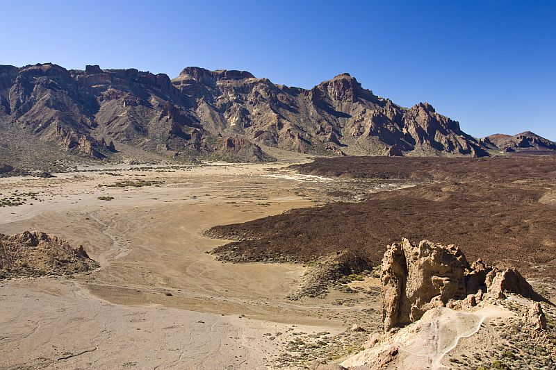
Roques de Garcia are a group of rock formations (pinnacles) in the Las Cañadas caldera. This caldera is a large depression (16 km) that surrounds the highest peak of Tenerife (El Teide or Mount Teide) that rises 3718 meters above the sea level. The caldera floor itself is about 2000…2300 meters above sea level.

The caldera of the Las Cañadas formed 200,000 years ago as a result of the collapse of the volcano with the same name1. The collapse was probably multi-staged and was not typical vertical collapse which is how calderas usually form. The caldera of the Las Cañadas is a result of a lateral flank collapse. Evidence of it lies on the seafloor north of Tenerife as an extensive debris avalanche deposit2. Hence, the caldera has no northern rim. The Las Cañadas caldera is one of the two calderas after which all other calderas are named. The other being in La Palma (Caldera de Taburiente). The term “caldera” was first used in geological sense by a German geologist Christian Leopold von Buch who visited the Canaries in 1815.

The focus of this post are the pinnacles at the foot of the Mount Teide which exhibit weird shapes and are therefore one of the most important tourist attractions of the island. I recommend to arrive early in the morning because later you will have difficulties to find a parking place. I knew that and therefore arrived early and enjoyed the landscape without huge crowds. It is also good idea to arrive early because light conditions for photography are better. Light at noon is generally too harsh for landscape photography.

It must be said, though, that the vast majority of people only take a look of The Cinchado and its surroundings right next to the car park. But there is much more than that to those who are interested in geology. There is a very scenic hiking trail around the Roques. It should not take more than one hour to walk it through but I had so much to look at there that it took at least three times as much time for me. I am sharing some of the photos I took there with you below.

http://picasaweb.google.com/107509377372007544953/Tenerife#5835129356901766066
Tenerife has been restless after the collapse which is clearly manifested by the magnificent peak of El Teide which rises prominently about 1500 meters above the floor of the caldera. All of it had to form during the last 200,000 years. The volcano is active. Its last eruption took place a little more than 100 years ago (1909) but this timespan is nothing special to volcanoes. El Teide will undoubtedly erupt again in the future. The pinnacles of the Roques de Garcia are on the lower right.

http://picasaweb.google.com/107509377372007544953/Tenerife#5835129353977621874
The pinnacles of the Roque de Garcia are the remnants of the collapse which are later modified by erosion. Most of them are composed of polylithic and generally matrix-supported volcanic breccia3. Such breccias are fairly common in the Canaries and demonstrate the gravitational instability of these islands. The most likely reason for this is the common development of near-surface magma chambers in the Canaries2 and quite possibly also highly evolved alkaline magma which brings along explosive volcanic eruptions.
http://picasaweb.google.com/107509377372007544953/Tenerife#5835129402231697250
By far the most famous of these pinnacles is The Cinchado. It is evident that sooner or later it will collapse under its own weight but fortunately the base of the structure seems to be still strong enough for many generations to enjoy the sight.
http://picasaweb.google.com/107509377372007544953/Tenerife#5835129436399408482
The Cinchado from another angle. There are many different layers of breccia and there seems to be two dikes near the top.
http://picasaweb.google.com/107509377372007544953/Tenerife#5835129403524547218
Close-up of a matrix-supported breccia. Width of view 1.7 meters.
http://picasaweb.google.com/107509377372007544953/Tenerife#5835129447254371874
Some breccia layers are clast-supported. Width of view 2 meters.
http://picasaweb.google.com/107509377372007544953/Tenerife#5835129393809505858
This pinnacle is a remnant of a dike with a phonolitic composition. It is me with my wife Tuul for scale. This pinnacle is actually very modest in size. Most of them are much taller.
http://picasaweb.google.com/107509377372007544953/Tenerife#5834897212919943922
Pinnacle composed of breccia with a pahoehoe-like lava flow in front of it.
http://picasaweb.google.com/107509377372007544953/Tenerife#5835129426192891250
There are lots of dikes cutting through the breccia beds.
http://picasaweb.google.com/107509377372007544953/Tenerife#5835129464601473282
Here is one dike nicely exposed at the surface.
http://picasaweb.google.com/107509377372007544953/Tenerife#5835129469027306322
And here it gets really magnificent. Dikes are forming huge thick walls of rock.
http://picasaweb.google.com/107509377372007544953/Tenerife#5835129351828238290
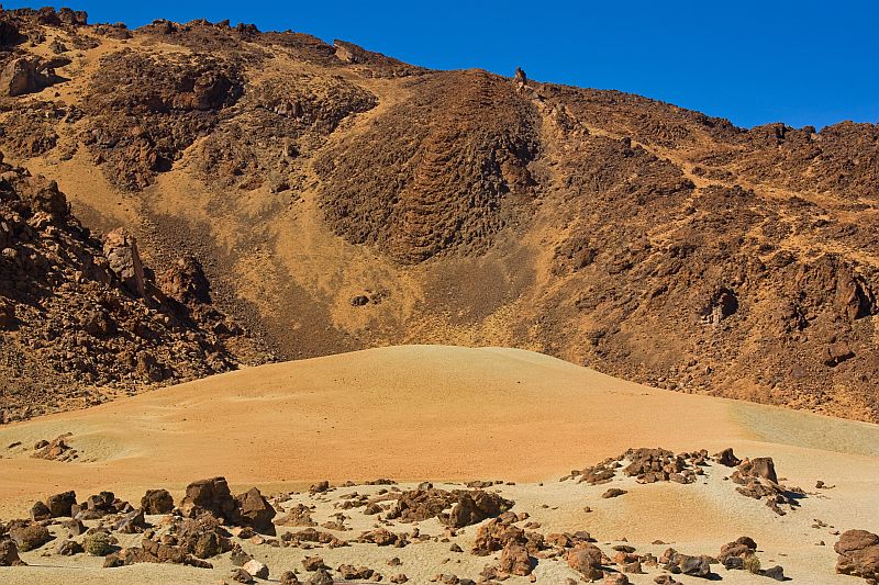
Trachybasaltic pahoehoe lava flow from The Teide cascading down the breccia cliff.
http://picasaweb.google.com/107509377372007544953/Tenerife#5835129490711860082
Lava flow and the peak of Mount Teide itself in the background.
http://picasaweb.google.com/107509377372007544953/Tenerife#5835129509286973346
It may not be easily understood from this photo but there are three pinnacles in this photo. The middle one is behind the other two and it is an igneous intrusion which is demonstrated by columnar jointing. Columns are always perpendicular to the cooling front. So it can be used to determine the orientation of the intrusion.
http://picasaweb.google.com/107509377372007544953/Tenerife#5835129502598800754
Here again is a nice example of columnar jointing but this time we can see the ends of the columns which give us a hint that this intrusion may be a neck (former volcanic vent or other pipelike intrusion).

A view from The Roques to the caldera floor which is covered by alluvium and aa lava. The rim of the caldera in the background.

References

1. Hoernle, Kaj & Carracedo, Juan-Carlos (2009). Canary Islands, Geology. In: Encyclopedia of Islands (Encyclopedias of the Natural World) (Ed. Gillespie, Rosemary G. & Clague, David A.). University of California Press. 133-143.
2. Schmincke, Hans-Ulrich (2005). Volcanism. Springer.
3. Gill, Robin & Thirlwall, Matthew (2012). Tenerife Canary Islands: Geologists’ Association Guide: No.49. The Geologists’ Association.

Pinnacle of breccia in Tenerife

There are interesting pinnacles of lithic breccia on the bottom of the Las Cañadas caldera which is surrounding Mount Teide — the highest peak of Tenerife. They are known as Roques de Garcia. This formation involves more than just breccia. There are also dikes, necks, lava flows and other interesting phenomena. By far the most famous of these formations is The Cinchado which is considered by some to be the most photographed rock. I plan to write a longer post with pictures of these beautiful landforms. Today I am showing just one pinnacle as an appetizer. Here is the longer post: Roques de Garcia.

http://picasaweb.google.com/107509377372007544953/Tenerife#5834897212919943922
Here it is. A pinnacle of lithic breccia on top of the caldera floor some 2100 meters above sea level. I don’t know how high it is but to give you a scale I would guess that perhaps 30 meters or so.

It is not fully understood whether this material represents volcanic debris avalanche deposit or is it even laharic in origin. It is generally believed that the former is more likely because the matrix is not muddy enough for it to be lahar and volcanic debris avalanches are quite common in the Canaries. The Las Cañadas caldera itself is a result of a lateral flank collapse of the Las Cañadas volcano which most likely was higher structure than the edifice of Mount Teide is today. These pinnacles are the remnants of the collapse of the Las Cañadas volcano. Pahoehoe-like lava in the foreground has a composition of trachybasalt1.

References

1. Gill, Robin & Thirlwall, Matthew (2012). Tenerife Canary Islands: Geologists’ Association Guide: No.49. The Geologists’ Association.

Coulee like a huge pahoehoe

The photo below was taken in the Las Cañadas caldera, which is surrounding the highest peak of Tenerife (Mount Teide). You can see a small hill composed of pumice lapilli and very nicely exposed example of coulée flowing down the mountain in the background.

Coulée
It is difficult to estimate the width of the coulée but I think I am not very much mistaken if I say that it was between 50 and 100 meters at the widest part.

What is coulée? This word has several meanings. I am referring to volcanic landform, which is an intermadiate stage between lava dome and lava flow.

Lava that forms coulée is too viscous to flow like a normal lava. It should form a dome instead, but sometimes domes form on steep flanks of volcanoes and get deformed by gravitation. This example is composed of glassy lava. The interior of it was still partially molten and moved slowly downhill and dragged along the glassy exterior which got warped like a surface of a huge ropy pahoehoe lava flow.

Coordinates of the coulée and a plain of pumice lapilli: 28° 15′ 54″ N 16° 35′ 22″ W. Altitude 2300 meters.

Block-and-ash flow deposits

Block-and-ash flow deposit is a pyroclastic flow deposit consisting of large fraction of juvenile volcanic blocks in a matrix of volcanic ash of the same composition1. Block-and-ash flow deposit is a type of ignimbrite as all deposits of pyroclastic flows are considered to be ignimbrites, regardless of whether they are welded or not2.

Pyroclastic flow is a very hot (up to 1000 °C) mixture of volcanic gases, ash, and blocks that runs rapidly downhill and spreads quickly under gravity. Pyroclastic flows are ground-hugging as they are denser than air. Pyroclastic flow is the deadliest expression of volcanism followed by lahars3.

Pyroclastic flow deposits show a considerable variation in texture and composition. They may be generated by several mechanisms. Block-and-ash flows are mostly the result of a collapse and fragmentation of volcanic domes3. Collapse of oversteepened dome may be either gravitational, explosive, or both at the same time. Well known volcanoes producing lava domes and block-and-ash flows are Unzen (Japan), Merapi (Indonesia), and Montserrat (British overseas territory in the Caribbean)1. Such collapses produce lots of angular juvenile volcanic blocks and are accompanied by a powerful volcanic blast generated by the release in pressure which produces volcanic ash and liberates lots of hot gas.

Pyroclastic flow deposits (sometimes also known as pyroclastic density current or PDC4) may cover huge areas (up to 50 000 km2 in extreme cases) but block-and-ash flows are confined to much smaller area because there is simply not enough blocks. Block-and-ash flows may extend up to 10 km from their source and they travel at speeds up to 100 km/h. Block-and-ash flows are usually 1-10 meters in thickness1. They may be either clast- or matrix-supported (clast-supported means that individual clasts are in contact).

http://picasaweb.google.com/107509377372007544953/Tenerife#5829978158983537218
Blocks stand out because the matrix is less resistant to erosion.

http://picasaweb.google.com/107509377372007544953/Tenerife#5829978170639255650
Most of the blocks are about 10-25 cm across but some may extend over one meter.
http://picasaweb.google.com/107509377372007544953/Tenerife#5829978169737834114
http://picasaweb.google.com/107509377372007544953/Tenerife#5829978197683094354
http://picasaweb.google.com/107509377372007544953/Tenerife#5829978206680225074
There is a sharp contact with the underlying darker layer of pyroclastic rocks.
http://picasaweb.google.com/107509377372007544953/Tenerife#5835569151026130866
Deposit in Tenerife which has lots of polymictic blocks embedded in ignimbrite. However, it is most likely lithic breccia, not block-and-ash flow deposit because it has lots of pumice clasts in it. True block-and-ash events are formed by non-explosive dome collapses and contain very little pumice. Read more about this outcrop: Block-and-ash flow deposit or lithic breccia? Width of view 0.8 meters.

Here are the coordinates of the exposure in Gran Canaria if you would like to visit it: 28° 08′ 26″ N 15° 29′ 33″ W. It is a middle section of a coastal cliff about 10 meters above sea level but it is accessible after some climbing on the rocks. It was unexpected find for me.

References

1. Freundt, A. & Wilson, C. J. N. & Carey, S. N. (1999). Ignimbrites and Block-And-Ash Flow Deposits. In: Encyclopedia of Volcanoes (Ed. Sigurdsson, H.). Academic Press. 581-599.
2. Tilling, Robert I. (2007). Ignimbrite. In: McGraw Hill Encyclopedia of Science & Technology, 10th Edition. McGraw-Hill. Volume 9. 20-21.
3. Schmincke, Hans-Ulrich (2005). Volcanism. Springer.
4. Francis, P. & Oppenheimer, C. (2003). Volcanoes, 2nd Edition. Oxford University Press.

Don’t visit Cumbre Vieja in wintertime

Cumbre Vieja is a chain of volcanic edifices which form the spine of a wedge-shaped La Palma. It is one of the most active volcanoes on Earth. It was high on my list of places to go but unfortunately the weather on this rift (mostly little less than 2000 meters high) was miserable the whole time I spent on the island.

It really does not matter much whether it is summer or winter if you plan to spend your days on a beach. However, it is entirely different story when you plan to go up in the mountains. I postponed going there several days. Finally I decided to go anyway, no matter what is going on there because time was running out. I did about 15 km hike with a climb of 800 meters. It rained the whole time but when I got up on the rift it was getting real crazy.

Wind was so strong that rain fell almost horizontally and temperature was far from being hot. Combination of strong wind, constant rain, and cold air temperature is quite hard to tolerate. I had no gloves. I tried to protect my bare hands in pockets but my hiking pants were all wet although these damn things should theoretically be waterproof. It was painful to take photos and camera was useful only for close range shots because visibility was very bad.

I tried to take samples of lapilli but I could not open ziploc bags. I just tossed some into my backpack. My fingers were too clumsy because of cold. When I finally got back to my car it was difficult to undone shoelaces. Seriously, I just could not move my fingers to do it. This was quite extreme and definitely not what people imagine when I say that I just came from the Canaries.

But memories like that are worth collecting because adventures will be remembered but hardships will pass as soon as fingers are moving again. However, because of this trip I believe I will visit La Palma in the future again. This rift is very interesting but I want to enjoy it in nice weather. This time I did not see much at all. It has to be summer, I guess.

http://picasaweb.google.com/107509377372007544953/Tenerife#5828535056528953826
This picture of a volcanic bomb (about 15 cm across) is the best picture I managed to take.
http://picasaweb.google.com/107509377372007544953/Tenerife#5828535060480550882
Driving down from Cumbre Vieja. Not much visibility at all.

Aa lava

Aa lava is a rough rubbly crust of a lava flow. It is a major lava flow type. Other important subaerial lava flow types are pahoehoe and blocky lava.

Aa and pahoehoe are terms that were brought to geological terminology from the Hawaiian language. Aa is according to native Hawaiians a sound one makes if he or she tries to walk barefoot on such a lava flow. There are different spelling versions, ‘a’a, a’a, a-aa are used as well as simple aa. Pahoehoe means in Hawaiian “on which one can walk”2.

Walking on it is very slow and potentially dangerous even if one has good hiking boots. It is such a miserable experience because the uppermost part of aa lava is composed of loose clinkery unstable blocks. You can never be sure that the rocks you are stepping on do not move. They often do. This means that ground beneath your feet is unstable and you may easily lose balance. It is no good if that happens because the edges of fresh aa lava rubble may be very sharp. Sometimes aa lava blocks are so big that one has to climb over them. It makes moving progress very slow and bare hands will get scratched for sure.

One thing that in my opinion is often poorly understood is the fact that aa and pahoehoe are terms that only describe the upper part of a lava flow. It is more correct to say that aa lava is a type of lava flow crust, not lava flow itself. Both aa lava and pahoehoe are usually massive beneath the crust which may be smooth (pahoehoe) or rubbly (aa). Massive part usually contains vesicles (gas bubbles) which will fill with secondary minerals like zeolites in older lava flows. This process takes considerable time and requires low-temperature hydrothermal alteration. There are no amygdules (vesicle filling mineral masses) in historic lava flows.

Aa lava is more common than pahoehoe. Special conditions are needed for pahoehoe to form: lava with low viscosity (high temperature, low silica content), low effusion rate, and gentle slope. Aa lava is free of such restrictions and therefore forms instead of pahoehoe if the conditions are not right. It is usually the speed of advancing lava flow that determines whether aa or pahoehoe forms and that depends on the effusion rate and steepness of the slope. It has been shown that flow rates exceeding 5-10 m3/s clearly favors the formation of aa lava over pahoehoe on Hawaii1. Once aa lava is formed it never reverts back to smooth pahoehoe form.

References

1. Francis, P. & Oppenheimer, C. (2003). Volcanoes, 2nd Edition. Oxford University Press.
2. Schmincke, Hans-Ulrich (2005). Volcanism. Springer.

Pahoehoe lava

Pahoehoe is a smooth and continuous lava crust. Other main subaerial lava flow types are aa lava and blocky lava.

Pahoehoe forms when the effusion rate is low and consequently the velocity of lava flow is slow1. Pahoehoe lava flow is usually at least 10 times slower than typical aa lava flow4. Higher effusion rate results in lava flow being shattered which is how the rubbly and clinkery aa lava surface forms. Pahoehoe and aa lava are strikingly different in appearance but their composition may be identical or very similar. Lava flow that was originally pahoehoe may transform into aa lava but the reverse is impossible — once lava crust is broken it can not return back to smooth and continuous form2.

Only low-viscosity (usually basaltic) lava can form pahoehoe. Aa lava is much more common and is not as picky about the composition of lava flow. Aa lava can be basaltic, andesitic, tephritic, etc. Blocky lava needs more felsic compositions (silica content generally over 55%). Blocky lava is composed of larger blocks than aa lava and these blocks have much smoother surface.

Best known examples of pahoehoe lava flows are from the Big Island of Hawaii and the term ‘pahoehoe’ itself (just as ‘aa’) originates from the Hawaiian language. Pahoehoe is also known as ropy lava and it has several more varieties named entrail, festooned, filamented, sharkskin, shelly, etc3.

Glowing pahoehoe lava flow
Hot basaltic pahoehoe lava in Hawaii.
Solidifying basaltic lava flow.
Hawaiian lava from the Kilauea volcano (Pu’u O’o vent).
This pahoehoe formed on La Palma, Canary Islands during the eruption of Cumbre Vieja rift in 1949 (Hoyo del Banco vent). These examples of pahoehoe can be also described as ropy lava. Pahoehoe lava is not common on La Palma. Most fresh lava flows there have highly irregular surfaces typical to aa lava. I found these nice examples of pahoehoe while trying to walk on a lava flow formed in 1949. I said trying because aa lava makes very difficult and even dangerous walking. Its surface is irregular and uppermost clinkery part of it is usually loose. One has to be very careful not to lose balance because fresh lava surface is sharp and can easily cut deep wounds on bare hands.

References

1. Walker, George P. L. (1999). Basaltic Volcanoes and Volcanic Systems. In: Encyclopedia of Volcanoes (Ed. Sigurdsson, H.). Academic Press. 283-289.
2. Francis, P. & Oppenheimer, C. (2003). Volcanoes, 2nd Edition. Oxford University Press.
3. Jackson, J. A. (1997). Glossary of Geology, 4th Edition. American Geological Institute.
4. Kilburn, Christopher R. J. (1999). Lava Flows and Flow Fields. In: Encyclopedia of Volcanoes (Ed. Sigurdsson, H.). Academic Press. 291-305.

I am back from the Canaries

Hello again. I’ve been away from blogging for some time. This time was very busy and interesting for me. I spent two wonderful weeks on two beautiful volcanic islands — La Palma and Gran Canaria. I took more than 1000 photos and saw a wide variety of nice geology. I am eager to share it with you but it will take some time and many posts.

I said before taking the trip that hopefully I can write some field reports but it did not work that way. Internet is unfortunately not widely available there yet and my life mostly in the wilderness also made blogging very difficult if not impossible.

What did I see there? It’s a long list but here are some guidelines: lots of lava flows (aa, pahoehoe), alkaline volcanic rocks (phonolite, basanite, etc.), beautiful ignimbrites, various volcanic edifices (mostly cones made of lapilli), porphyritic rocks, many brecciated rocks, pyroxenite xenoliths, dikes, etc.

I spent most of the time on La Palma. Mainly because it is younger than Gran Canaria and volcanically very active with many nice examples of recent volcanism. I have now visited three islands of the Canary archipelago and I really have to say that they are all quite distinct. Each of them has something interesting which is missing on other islands of the archipelago. I am sure that in the future I will go to see the remaining ones which I have not visited yet.

http://picasaweb.google.com/107509377372007544953/Tenerife#5820052691065584594
I am near the Roque Nublo on Gran Canaria about 1700 meters above sea level.

Folds at Loughshinny

Loughshinny is a village in Ireland, about 15 km north of Dublin. This place has a very nice exposure of folded sediments from the late Carboniferous1.

Folded cliff is easy to access but one should really take care to visit the place during low tide. It was high tide when I first arrived to the scene. As you can see, it was hard to take a good photo without getting very wet:

http://picasaweb.google.com/107509377372007544953/Rocks#5805178655900228274
Folds are really spectacular. They have angular hinges and northern limbs are overturned. The mountain building event that is responsible for this deformation is the Variscan orogeny.
http://picasaweb.google.com/107509377372007544953/Rocks#5805178645688019154
Folded sediments are turbidites. Dark layers represent fine-grained mudstone. Lighter layers are somewhat coarser. The whole sequence is calcareous, there are many calcite veins cross-cutting it.
http://picasaweb.google.com/107509377372007544953/Ireland#5758425855166713266
I left the folds at Loughshinny to see other places but I really wanted to take a better picture and see more. So I came back about 6 hours later and the whole scene was very much different. The coastline was several hundred meters away from the cliff and I was able to take many more photos and wander along the coast as long as needed.
http://picasaweb.google.com/107509377372007544953/Rocks#5805178660226364258
These are really crazy folds, the best I have seen so far.
http://picasaweb.google.com/107509377372007544953/Rocks#5805178689226579650
The folds are plunging towards the sea. White veins visible on top of the shale layer are composed of calcite.
http://picasaweb.google.com/107509377372007544953/Rocks#5805178727180823538
http://picasaweb.google.com/107509377372007544953/Rocks#5805178728877061746
http://picasaweb.google.com/107509377372007544953/Rocks#5805178601386649106
Here is a piece of shale from Loughshinny. White is calcite. Width of sample 10 cm.
http://picasaweb.google.com/107509377372007544953/Ireland#5758425967760011570
I paid most of my attention to the rocks but I noticed that something weird is going on in the beach sand as well. If you want to know what it is then take a look at the post I’ve written before: Thousands of sand sculptures.

Here are the coordinates of a car park in case you wish to visit the place: 53° 32′ 49″ N 6° 04′ 45″ W. The folds are a few hundred meters to the southwest.

References

1. Stillman, C. & Sevastopulo, G. (2005). Leinster (Classic Geology in Europe). Dunedin Academic Press.

Ancient lahar in Ireland

Lahar is a mudflow on the flanks of a volcano. It consists of mud and fragments of volcanic rocks plus any other available material. It is loose sediment and most examples photographed are recent. I want to demonstrate you a lahar that is hundreds of millions of years old (probably from the Carboniferous). It is a hard greenish rock resembling moderately altered basalt or andesite but it contains lots of clasts which are mostly volcanic but there is fair amount of limestone fragments as well.

http://picasaweb.google.com/107509377372007544953/Ireland#5759869328170930178
Muddy matrix with volcanic clasts.
http://picasaweb.google.com/107509377372007544953/Ireland#5759869689480296242
This lahar is exposed at the coast.
http://picasaweb.google.com/107509377372007544953/Ireland#5759869647421940770
There are lots of clam shells.
http://picasaweb.google.com/107509377372007544953/Ireland#5759869875097211074
http://picasaweb.google.com/107509377372007544953/Ireland#5759869247067310386
http://picasaweb.google.com/107509377372007544953/Ireland#5759869591583801874
Conglomerate boulder on top of lahar.
http://picasaweb.google.com/107509377372007544953/Ireland#5759869897150058354
http://picasaweb.google.com/107509377372007544953/Ireland#5759870083300858514
Pink clasts are limestone fragments.
http://picasaweb.google.com/107509377372007544953/Ireland#5759870150028765010
http://picasaweb.google.com/107509377372007544953/Ireland#5759870135525906834

Want to visit the place? Here are some guidelines. Go to Portraine (north of Dublin) and park by the sea in a parking lot with the following coordinates: 53° 29′ 22″ N 6° 05′ 56″ W. Go few hundred meters to the north/northwest.

This is my 200th post on Sandatlas.