Bread-crust bomb

Bread-crust bomb is a type of volcanic bomb. Its characteristic feature is a crust disrupted by many cracks which resembles crust of some breads.

Bread-crust bombs are believed to form when viscous gas-rich lava is ejected from the volcanic vent. The exterior of the bomb solidifies quickly while the soft interior continues to expand because of gases that exsolve from the lump of lava. Just like in baked loaf, the internal expansion causes the brittle outer crust to crack1.

http://picasaweb.google.com/107509377372007544953/Hawaii#5868866983042219042
A bread-crust bomb resting near the summit of Mauna Kea, Hawai’i at an altitude of 4100 meters. Width of the bomb is 26 cm.

References

1. Francis, P. & Oppenheimer, C. (2003). Volcanoes, 2nd Edition. Oxford University Press.

Highest lake in Hawaii

Hawaii is not particularly famous for its lakes. To be honest, I remember only one — Lake Wai’au. But this one is rather special. At least for the native Hawaiians who consider it a sacred site.

What makes this lake so special? It is the fact that its surface is at an altitude of 3970 meters which makes it an alpine lake. It is very close to the summit of Hawai’i — Mauna Kea (4205 m). Air is thin there and walking not nearly as easy as it is near the sea level.

Lake Wai’au is really very small. Perhaps it should be called a pond instead of lake. Wikipedia says that it is about 100 meters across but I saw much smaller water body, perhaps 60 meters across. It was evident that the water level fluctuates because the surrounding ground was soft and muddy. It is surprising that the lake is so small in spring but the whole summit of Mauna Kea (which means “white mountain” because of its snow cover) was almost free of snow. I guess it was just poor winter there without much precipitation.

Alpine lakes usually have beautifully deep blue color. This one had beautiful color as well but not blue. It was green. I am not sure what is the cause of the coloration. Perhaps algae or bacteria. There is lots of solar radiation for these photosynthetic living forms but they also generally prefer warmer water. What ever the cause but thin air, blue sky, and green water was a beautiful combination to admire. I hope that the photo below is able to show the beauty of the scene.

http://picasaweb.google.com/107509377372007544953/Hawaii#5868569724564342706

You can access the lake after a short walk uphill and then down. Coordinates of the parking lot are 19.810409, -155.46768. Lake is on the other side of the road about 1 km away but it seems farther away because high altitude makes hiking somewhat harder.

America from above

It has been almost always cloudy when I fly somewhere. When I started my long journey from Istanbul to Los Angeles it was clear at the very beginning but things changed soon and northern Europe and Greenland were below thick layer of clouds, as always. But it changed when I was flying over northern Canada and weather remained calm and clear until the end. So I had an opportunity to do some aerial photography of interesting features or noteworthy places. It was great fun and made the second part of this 14-hour flight an enjoyable tour of American geology.

http://picasaweb.google.com/107509377372007544953/California02#5867815508353811586
This is Canada. The most striking thing is the immense number of lakes. I seriously doubt that anyone has ever counted them. We flew several hours over vast expanses of bogs, lakes and forests but I saw very few traces of man-made structures like roads, crop fields or towns. Almost nothing. This part of Northern America resembles northern Scandinavia but dimensions are much different. The rugged outline of the lake and lots of islands indicate that it is surrounded by hard crystalline rocks.
http://picasaweb.google.com/107509377372007544953/California02#5867815513814502610
Now we are over southern Canada and the scene is very different. Straight lines and rectangles clearly demonstrate that this landscape is influenced by intelligent beings who are in love with euclidean geometry. There are crop fields waiting for the spring to arrive and lots of other man-made structures.
http://picasaweb.google.com/107509377372007544953/California02#5867815509984695298
Nicely meandering river with oxbow lakes. It is still probably somewhere in southern Canada. Update from a comment written by Howard Allen: It is the junction of the North and South Saskatchewan Rivers, east of Prince Albert, in central Saskatchewan (53.235305, -105.083257). Interesting geological note, just a few miles to the east of this point is the very interesting Fort a la Corne kimberlite complex, one of the best-preserved kimberlite volcano complexes in the world.
http://picasaweb.google.com/107509377372007544953/California02#5867815537485258818
This mountainous scene is located in Montana, USA. It is probably Beartooth mountain range where is located the geologically famous Stillwater igneous complex.
http://picasaweb.google.com/107509377372007544953/California02#5867815547463740114
Another geological hot spot — Yellowstone Lake.
http://picasaweb.google.com/107509377372007544953/California02#5867815549790411666
Nice isolated mountain but I don’t know the name of it or where exactly it is located. It has to be somewhere between Yellowstone and Great Salt Lake. Update by Howard Allen: It is Blacktail Butte, north of Jackson, Wyoming (43.636993, -110.691438).
http://picasaweb.google.com/107509377372007544953/California02#5867815565399767090
Another meandering river but this one is already free of ice cover.
http://picasaweb.google.com/107509377372007544953/California02#5867815578683671826
And yet another sign of a rapidly approaching spring. Southern slopes of mountains are already free of snow while the northern slopes are snow-covered.
http://picasaweb.google.com/107509377372007544953/California02#5867815579462209618
Utah Lake and city of Provo behind it. Provo is a hometown of this website. Servers that host Sandatlas are located in this city.
http://picasaweb.google.com/107509377372007544953/California02#5867815590200338482
There are some reddish cliffs in the background. This is probably sandstone of the Colorado plateau.
http://picasaweb.google.com/107509377372007544953/California02#5867815597975127586
Lake Mead.
http://picasaweb.google.com/107509377372007544953/California02#5867815606396015874
Probably Kelso Dunes already in California.

When one tries to connect these points with a line it becomes apparent that it is not straight. It is normal that shortest flight paths appear to be curved on a two-dimensional map but the curvature needs to be convex in this case, not concave. Already when flying I noticed that we deflect to the left from the ideal course. I expected to see the entire Great Salt Lake but we actually flew over Salt Lake City and the lake was on another side of the plane. I think it is so because we were flying around the Edwards Air Force Base in California which is closed for commercial airplanes.

Intro to my California trip

My monthlong trip to Hawaii and California is over. I saw lots of beautiful places, covered thousands of miles and took many photos which I am eager to share with you. This post serves as an introduction to my twelve days in California.

There is little doubt that it was the best geotrip I’ve had so far. I saw many classic examples of geology which are usually shown in geology textbooks like pahoehoe from Hawaii, debris flow fans in Death Valley, and tufa towers of Mono Lake to name just a few. I saw everything I wanted to see in Hawaii (erupting volcano, green sand beach, mantle xenoliths, etc.) and in California I actually saw more than I planned. I did not believe when planning the trip that I have time to take a look at the largest trees in the world in Sequoia NP and see the beautiful landscape of Yosemite but I managed to press these into my plans as well. It is needless to say that twelve days is not enough to get to know California and its geology well but I got a taste of it and really liked it very much. So much that I definitely plan to return in the future. I will return to USA already within this year but it will be a different trip to a different place. I will write about that later when the time is right.

http://picasaweb.google.com/107509377372007544953/California02#5867496428932872882
Red Rock Canyon State Park was my first destination. It was conveniently on the road from LA to the Owens Valley and well worth a visit. It has many nice outcrops of sandstone and mudstone.
http://picasaweb.google.com/107509377372007544953/California02#5867496534395740962
It was very variable trip and not only geologically. I experienced freezing cold high in Sierra Nevada, dry heat in Death Valley and strong winds in many places. This particular morning and especially the preceding night near Obsidian Dome were quite cold. It is no wonder because this place is about 2,500 meters above sea level. I discovered that night that my old sleeping bag is no longer an adequate protection from temperatures like that. I believe it was -10 °C and I couldn’t sleep after about midnight because of cold. So I was up as soon as it was light enough. This photo was taken during the early morning hours. You can see a nice boulder of obsidian with gray pumice. Road to this place was still blocked with snow. So I had to take a 6 km hike but did so happily because it was a great way to get some warmth.

Mono Lake and many interesting geological features around it was one of the highlights of my trip. Here you can see tufa towers which grew in the lake when the water level was higher. These limestone (tufa is a type of soft limestone) towers form because the lake water is rich in carbonate ions which combine with calcium brought into the lake by springwater.

http://picasaweb.google.com/107509377372007544953/California02#5867496987590425842
American roads tend to be often straight and usually surprisingly wide. This is not something I am used to see because roads in Europe are much more winding and generally narrower also. This road descends to Death Valley from northern direction. I visited Eureka Dunes before and was on the way to see the rest of the valley.
http://picasaweb.google.com/107509377372007544953/California02#5867496986905606818
This place is near Racetrack Playa with its sliding rocks. I believe that the name “Teakettle Junction” is older and the tradition to hang teakettles there came later but who knows. Nice tradition anyway.
http://picasaweb.google.com/107509377372007544953/California02#5867497002039417346
Sand dunes near Stovepipe Wells right before sunset.
http://picasaweb.google.com/107509377372007544953/California02#5867497010590580706
Oh, these American roads. They can be a lot of fun. I can understand now why so many Americans prefer to drive 4×4 vehicles. It is a necessity in many cases. I am not wealthy enough to afford to rent these. So I have to be careful when choosing which roads to drive with a smaller car. I had no plan to go and see the Lippincott Pass but I did take a trip over the Red Pass in another range which was theoretically driveable with a 2WD car but in reality was only very barely so.
http://picasaweb.google.com/107509377372007544953/California02#5867497008540006930
I don’t know exactly what it symbolizes. Perhaps solitude and desolation because it is in one of the ghost towns. This ghost town is named Rhyolite and it is located in southern Nevada. So in addition to Hawaii and California I also visited Nevada although very briefly. I was drawn into this town partly because of its name (rhyolite is a rock type) and mostly because I just wanted to see how a ghost town in America looks like. I have to say that what I found there was disappointing. Perhaps I had an illusion of something western-like but this town seems to be younger and it has just some ruined houses. Nothing very special except this wooden structure which was the funniest thing I saw in Rhyolite.
http://picasaweb.google.com/107509377372007544953/California02#5867497039413224818
I spent most of my time in California behind the mountain ranges which makes climate very dry there. But during the last days of my trip I also saw much more populous areas of California which have more human-friendly climate. On this picture is an orange tree growing in Central Valley near the Sierra Nevada mountain range. To me it is strange to see a tree with blossoms which also carries ripe fruits. Maybe someone can explain this to me.
http://picasaweb.google.com/107509377372007544953/California02#5867497044249579026
Nice to see that some old cars are still moving. I would not choose this one as my four-wheeled companion on a geotrip but it is a delight to see those on the road.
http://picasaweb.google.com/107509377372007544953/California02#5867497049453877778
Sierra Nevada is mostly composed of granitoid igneous batholiths. This one is probably granodiorite and it hosts a nice inclusion of diorite (10 cm in length). Such inclusions are really abundant. I found them in many places and on both sides of the range.

Flowing lava of Pu’u O’o

Aloha!
I just wanted to say that I am still among the living ones and having a great time. I have spent the past 10 days or so in Hawai’i (The Big Island). I saw there lots of interesting geology. I stayed at campsites overnight and had no Internet. So unfortunately I was not able to post anything there but I hope to make it up later when I am home again. But it will take some more time because I am not finished yet. Currently I am in O’ahu at a hostel where internet is available and I can start to show you my pictures taken in Hawai’i. But soon I will go to California for about ten days and during that time I am most likely just as disappeared as I’ve been during the past two weeks. I am not even sure that there is a mobile phone coverage in areas I plan to visit like Death Valley and several other interesting but remote places.

One of the reasons to visit Hawai’i was to see living, moving and glowing lava up-close. Hawaii is probably the best place in the world to do this. I did achieve this although it was much more difficult than I imagined. Lava is currently flowing in a remote place far away from any houses or roads. To get there, I needed to hike over four miles of rough lava fields. It was really wonderful experience and I plan to write about my adventures on the lava field in a separate post when I have more time. Right now just a couple of pictures of glowing lava which comes from the Pu’u O’o vent on the southeastern flank of Kilauea. Lava is flowing there mostly in a lava tunnel but in some places it breaks onto the surface for us to enjoy the sight.

http://picasaweb.google.com/107509377372007544953/Rocks#5861729624290638754
It may be difficult to believe but it is easy to accidentally wander onto active lava flow. Its upper crust is solid. It loses heat rapidly and is only warm to the touch. It insulates the red hot interior well from the cooling atmosphere.
http://picasaweb.google.com/107509377372007544953/Rocks#5861729631102422274
In some places flowing viscous mass of basaltic melt breaks free and flows as a thick tongue of lava.

Glowing pahoehoe lava flow
Note how rapidly lava loses heat and turns black. It happens about 30 seconds after flowing out onto the surface.

http://picasaweb.google.com/107509377372007544953/Rocks#5861729639091673586
Some flows were pretty impressive. This glowing river of lava is more than 5 meters wide.
http://picasaweb.google.com/107509377372007544953/Rocks#5861729650462407554
I am obviously satisfied with this. I made it although the trip was difficult and hazardous. Solidified lava flows are often hollow inside and falling through it may result in a serious injury. Active lava flows are not particularly hazardous in Hawai’i but volcanic gas that also comes out of the ground with lava is a grave threat. I knew what I was doing although at times I sensed that things are not under my control as much as I wanted. Especially because of gas. I had to search for a good place where there is lava but relatively small amount of gas for some time and always had to make sure that wind was blowing the gas away from me.

Solidifying basaltic lava flow.
This is how new pahoehoe forms. Beautiful!

http://picasaweb.google.com/107509377372007544953/Rocks#5861729655418699138
I stayed well after the sunset to admire the glowing lava field in the darkness. And then moved upwind about half a kilometer to find some place to sleep. It was impossible to hike back in the darkness because my car was about 7 kilometers away.

Here are some videos of lava flows I took that day: Videos of flowing lava and longer overview of different lava flow types.

S-dike and SS-fold

While visiting Ireland I noticed small folds that resemble double S to me. This picture was first published on the Mountain Beltway blog written by Callan Bentley. One of my favorite blogs, by the way.

http://picasaweb.google.com/107509377372007544953/Rocks#5844142085079607474
It is such a sweet sight if you are interested in rocks and suddenly see your initials written in stone. I am flattered. The only problem is that this signature has been there for more than one billion years (it formed during the Grenville Orogeny). I guess it actually is not there to honour me.

When I visited La Palma in the Canaries I spotted something similar. This time there is only one S but it is made of dikes.

http://picasaweb.google.com/107509377372007544953/Tenerife#5844142137378108738
S-dike in La Palma in the Caldera de Taburiente. It would be very hard to explain why is dike folded like that but this is not necessary because there are actually three dikes that seem to form a letter S.

“Rainbow” of a scoria cone

Scoria cones (or cinder cones) are conical volcanic hills that are mostly composed of mafic vesicular lapilli (known as scoria) and other pyroclasts. They are very common volcanic landforms but I am not going to focus on them today. Instead I would like to show you a couple of photos that show how the color of scoria changes depending on the distance from the centre of the cone.

Fresh scoria is black, oxidized scoria is reddish brown. Below is a photo that shows reddish weathered scoria at the center of the La Montaña del Palmar scoria cone in northwestern Tenerife. There is a smooth gradation from black to reddish scoria which clearly demonstrates that this is the same material. The interior is just oxidized. But why?

The interior of the cone was very hot during its formation because there was the vent that fed the volcanic hill with liquid magma. It obviously had to be the contributing factor because only the interior which was once hot is oxidized. Another thing we need to oxidize scoria is water. So the answer is most likely that it was very hot water (steam) that was involved in the process.

http://picasaweb.google.com/107509377372007544953/Tenerife#5838222068781104594
Such a smooth gradation from black to oxidized red color is a common phenomenon but we only see it when someone has revealed the internal structure of the cone for us. In this particular case we can see it because there is a quarry which extends into the heart of the cone.
http://picasaweb.google.com/107509377372007544953/Tenerife#5838222073785823234
The cone is mostly composed of lapilli-sized pyroclasts but some of them are much larger (there are many embedded in smaller lapilli in the wall behind). These rocks are known as bombs. They were partially molten when thrown out of volcano. I am holding one bomb in my hands. Good thing with these bombs is that they don’t explode. It is pretty safe to handle one when it isn’t hot anymore and not flying through the air at high speed like a cannon ball.

The coordinates of the cone: 28° 20′ 22″ N 16° 51′ 01″ W. Altitude 900 meters.

Tenerife ignimbrite

Ignimbrite is a common rock in southern Tenerife. It has a characteristic light-colored look and seems to contain vesicules which are actually pseudovesicules. Tenerife ignimbrite does not look like ignimbrite from neighbor island Gran Canaria (pictures of Gran Canaria ignimbrite). Tenerife ignimbrite is unwelded and does not contain fiamme (flattened pumice clasts). There are numerous outcrops of ignimbrite in Tenerife. Here are some pictures of this beautiful rock formation.

http://picasaweb.google.com/107509377372007544953/Tenerife#5836571987685513522
Unwelded pumiceous ignimbrite in a quarry face. It was deposited approximately 600,000 years ago1.

http://picasaweb.google.com/107509377372007544953/Tenerife#5836571990457740930
Coordinates of the quarry: 28° 08′ 22″ N 16° 31′ 48″ W.
http://picasaweb.google.com/107509377372007544953/Tenerife#5836571997853181474
It may seem that ignimbrite is vesicular here but these holes were actually formerly filled with pumice clasts that have fallen off. You can see that many “vesicules” are still partly filled with pumice. Width of view is 40 cm.

Lapillistone, tuff, ignimbrite
There is a layer of pumiceous lapillistone below the ignimbrite and a layer of tuff (thickness 15-20 cm) separating them. All three layers are closely related and have the same phonolitic composition1. There are no soil layers between them. They were probably deposited from the same eruption column. I have written a separate post about the lapillistone: Granadilla pumice.

http://picasaweb.google.com/107509377372007544953/Tenerife#5835569151026130866
Ignimbrite may contain lots of lithic clasts. It is a different location which I described here: Block-and-ash flow deposit or lithic breccia?
http://picasaweb.google.com/107509377372007544953/Tenerife#5836602107388950546
Ignimbrite on the southern coast of Tenerife.
http://picasaweb.google.com/107509377372007544953/Tenerife#5836602111315406802
Close-up of the coastal ignimbrite reveales that it is quite rich in lithic clasts. Width of view is 24 cm.
http://picasaweb.google.com/107509377372007544953/Tenerife#5835287153442706386
Ignimbrite is locally used as a building material. It is light-weight and easy to cut and shape.
http://picasaweb.google.com/107509377372007544953/Tenerife#5835533261787961666
This wall seems to be made of artificial bricks but they are actually entirely natural blocks of ignimbrite. Quite possibly from the quarry shown above. See more stone walls in my building stone gallery.

References

1. Gill, Robin & Thirlwall, Matthew (2012). Tenerife Canary Islands: Geologists’ Association Guide: No.49. The Geologists’ Association.

Block-and-ash flow deposit or lithic breccia?

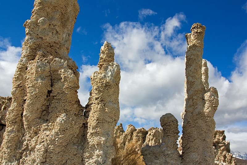
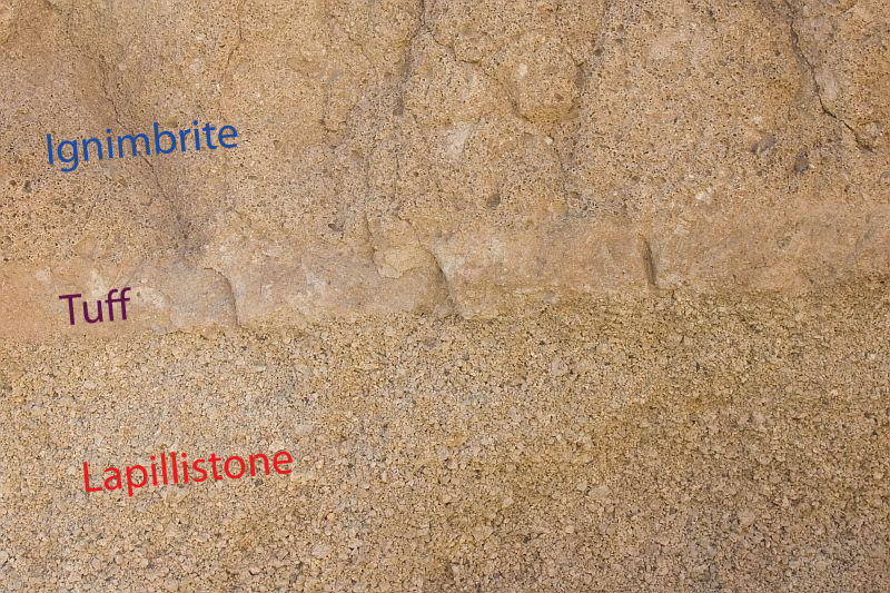
Large part of southern Tenerife is covered with ignimbrites and pumice fall deposits but these pyroclastic sediments contain only a small amount of lithic material (except pumice lapilli). However, in one short section of a roadcut I noticed something very different — many dark fragments embedded in usual cream-colored ignimbrite.

Not long ago I wrote about a block-and-ash flow deposit in Gran Canaria. This outcrop in Tenerife is somewhat similar. Clasts (blocks) do not stand out as they do in the outcrop in Gran Canaria and they seem to be more versatile (polymictic) but I believe that most likely it is yet another example of block-and-ash flow deposit because the clasts are clearly surrounded by ignimbrite (read also the update below which contradicts this hypothesis).

Block-and-ash flow deposits are not very extensive. They are usually 1-10 meters in thickness1 which seems to be the case here as well. I have a longer description of these interesting and fiery rocks in the article describing the Gran Canaria outcrop.

http://picasaweb.google.com/107509377372007544953/Tenerife#5835555293986279282

http://picasaweb.google.com/107509377372007544953/Tenerife#5835555291145908210
http://picasaweb.google.com/107509377372007544953/Tenerife#5835555299450784610
Width of view 1.6 meters.
http://picasaweb.google.com/107509377372007544953/Tenerife#5835569151026130866
Width of view 0.8 meters.

Here are the coordinates: 28° 13′ 59″ N 16° 26′ 12″ W. Altitude 370 meters. These coordinates refer to a parking place. The actual roadcut is few hundred meters down the road towards the coast. Be careful if you plan to visit the place because it is a roadcut and unfortunately there is not much room left for geologists.

It is a common problem in Tenerife. Roads are narrow and winding. It is very difficult to find a place to park a car. In this particular case I was actually lucky because the first opportunity to pull off was only few hundred meters away. Tenerife is a wonderful island geologically but it is densely populated. There are almost one million inhabitants living in a relatively small island plus hordes of tourists. Hence, most roads are quite busy.

Update

Volcanologist Paul Cole pointed my attention to the fact that there are pumice clasts in it which makes it unlikely to be a block-and-ash flow deposit. The problem is that true block-and-ash flows are formed by non-explosive dome collapses and contain very little pumice. Domes are not composed of pumice. Pumice is thrown out of volcanoes. Hence, it is more likely lithic breccia deposited from a pyroclastic density current.

Another aspect that makes this hypothesis more likely is the polymictic assemblage of the clasts. It is hard to explain how can one volcanic dome yield such a variety of clasts. It actually bothered me while I was inspecting the outcrop but because of my limited experience I could not think of any better explanation than a block-ash-flow event. So these rocks we see in the outcrop were most likely picked up by a ground-hugging pyroclastic flow while it was cascading down the flanks of a volcano.

References

1. Freundt, A. & Wilson, C. J. N. & Carey, S. N. (1999). Ignimbrites and Block-And-Ash Flow Deposits. In: Encyclopedia of Volcanoes (Ed. Sigurdsson, H.). Academic Press. 581-599.

Granadilla pumice

Tenerife has a wide variety of volcanic rocks: from mafic basanite and basalt to evolved phonolite and trachyte. Hence, eruption styles differ considerably as well: from pahoehoe lava flows to fiery ignimbrites and pumice showers. In this post I will show some photos of pumice fall deposit in the southern part of the island which is known as the Granadilla pumice.

This formation covers 800 km2 and is a result of a large Plinian eruption that took place 32,000 years ago1 (However, studies conducted later indicate that this formation is much older — 600,000 years2). It originates from the Las Cañadas caldera that surrounds the Mount Teide. This eruption involves not only pumice fall deposits but also ignimbrites which are described here: Tenerife ignimbrite.

The Granadilla pumice is composed of angular and very well sorted pumice lapilli with a phonolitic composition2. It is a clast-supported deposit with very little fine ash between lapilli. It is a lapillistone according to the classification principles of pyroclastic rocks because it contains more than 75% of lapilli3.

Such deposits settle from high buoyant eruption columns (ash clouds). There is so little ash because it is blown away downwind while the larger lapilli fell down and covered the landscape with a thick blanket of well-sorted pyroclasts.

http://picasaweb.google.com/107509377372007544953/Tenerife#5835477257723844770
Lapillistone (Granadilla pumice) has a grainy look because it contains little else than pumice lapilli.
http://picasaweb.google.com/107509377372007544953/Tenerife#5835477260570033682
Close-up of the Granadilla pumice. Shorter edge of the gray card is 6 cm in width.

Lapillistone, tuff, ignimbrite
Granadilla pumice below, layer of tuff (thickness 15-20 cm) on top of it and then ignimbrite. All three have the same phonolitic composition.

http://picasaweb.google.com/107509377372007544953/Tenerife#5835482892065455538
People make their stone walls with what they have got. In this case they had to be satisfied with pumiceous lapillistone. Here is my gallery of stone walls.

References

1. Booth, Basil (1973). The Granadilla pumice deposit of Southern Tenerife, Canary Islands. Proceedings of the Geologists’ Association, Volume 84, Issue 3, Pages 353–370.
2. Gill, Robin & Thirlwall, Matthew (2012). Tenerife Canary Islands: Geologists’ Association Guide: No.49. The Geologists’ Association.
3. Le Maitre, R. W. (2005). Igneous Rocks: A Classification and Glossary of Terms: Recommendations of the International Union of Geological Sciences Subcommission on the Systematics of Igneous Rocks, 2nd Edition. Cambridge University Press.